Open the map and every aircraft nearby appears in real time — tap one to see its altitude, speed, heading, route, an actual photo of that exact plane, and live weather along its path. Search by callsign, flight number, or now just an airline code — type "BA," "VS," or "U2" to pick from that airline's aircraft in view.
Hit Track Landing and get live approach alerts — Initial Approach, Final Approach, Undercarriage down — each with its own chime, building to a fanfare the moment it touches down.
This page centers a configurable-radius circle (10 mile radius by default) on your current location and shows any aircraft flying through that airspace right now, using free community ADS-B trackers. Allow location access, or search for a place below.
"What's Above Me?" (the "Service") is provided by Caltechnics ("Caltechnics", "we", "us"). By creating an account or using the Service, you agree to these Terms & Conditions ("Terms"). If you do not agree with them, please don't use the Service.
You must be at least 18 years old, and able to enter into a binding contract, to create an account or take out a subscription.
You can sign in with Google or a supported email and password. You're responsible for keeping your login details secure and for all activity on your account. Accounts are personal to you and may not be shared, sold, or transferred to anyone else.
Some features require a paid subscription. Where a free trial is offered, it currently runs for 7 days; unless you cancel before it ends, your payment method will then be charged the subscription price shown to you at sign-up, and billing continues monthly until you cancel. We may change our prices from time to time — any change applies to future billing periods, and we'll make reasonable efforts to give existing subscribers advance notice. You can cancel at any time from within the Service ("Manage subscription"); cancellation takes effect at the end of the billing period you've already paid for, and we don't provide refunds for the unused part of a period except where the law requires it.
At our discretion we may give certain accounts free or discounted access — for example for family, friends, or promotional purposes. We can withdraw or change this at any time.
The Service shows aircraft positions, routes, schedules, weather, and related details sourced from third-party APIs and community data providers, including community ADS-B receiver networks and public aviation datasets. All such data is supplied to us by those third parties, and we have no control over — and give no guarantee of — its accuracy, completeness, or timeliness. This data can be delayed, incomplete, estimated, or simply wrong, and coverage varies by location and aircraft.
The Service is provided for general interest and informational purposes only. It must not be used or relied on for air navigation, air traffic control, flight planning, or any other safety-critical or operational aviation decision. Always use official, certified sources for anything safety-related.
You agree not to: use automated tools to scrape, mirror, or bulk-extract data from the Service; try to reverse engineer, decompile, or bypass any technical protection or usage limit; resell, sublicense, or redistribute the Service or the data it shows; use the Service in a way that could interfere with, overload, or damage it (or the shared third-party data quotas it relies on); or use the Service for any unlawful purpose.
The Service, its design, and its underlying software belong to Caltechnics or its licensors, and are protected by copyright and other laws. We grant you a personal, non-exclusive, non-transferable, revocable licence to use the Service for its intended purpose. Nothing in these Terms transfers any ownership rights to you.
The Service relies on, and links to, third-party data providers and services. We don't control, and aren't responsible for, their availability, accuracy, or content, and using them may be subject to their own separate terms.
We may suspend or end your access to the Service, with or without notice, if we reasonably believe you've broken these Terms or used the Service in a way that could harm us, other users, or our third-party data providers. You can stop using the Service and cancel your subscription at any time.
The Service is provided on an "as is" and "as available" basis. We don't guarantee it will be uninterrupted, error-free, or available at all times, and we make no warranty about the accuracy, completeness, or reliability of any data it shows.
Nothing in these Terms excludes or limits our liability where the law doesn't allow us to (for example, for death or personal injury caused by our negligence, or for fraud). Subject to that, to the fullest extent the law allows, Caltechnics' total liability to you arising out of or in connection with the Service — whether in contract, tort, or otherwise — is limited to the amount you paid for your subscription in the single most recent monthly billing period. We aren't liable for any indirect or consequential loss, or for any decision made in reliance on data shown in the Service.
We may update these Terms from time to time. If we make a material change, we'll take reasonable steps to let you know — for example with a notice inside the Service. Continuing to use the Service after an update means you accept the new Terms.
These Terms are governed by the laws of England and Wales, and any dispute is subject to the exclusive jurisdiction of the courts of England and Wales.
Questions about these Terms? Contact us at info@caltechnics.com.
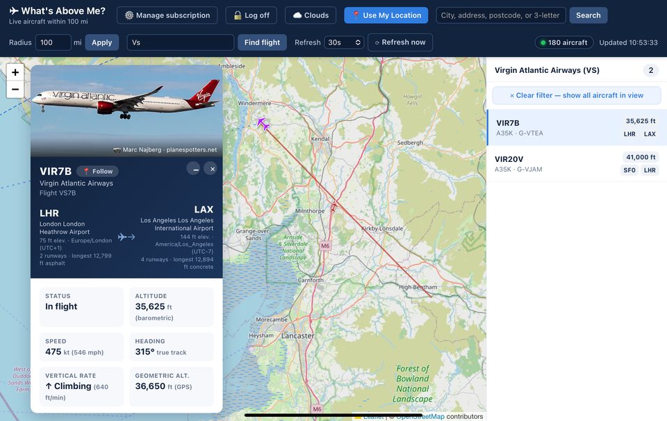
A live aircraft tracker. Open the map and every aircraft currently overhead appears in real time — tap one to see its altitude, speed, heading, aircraft type, registration, route, an actual photo of that specific aircraft, live weather along its path, and more.
Live positions come from community ADS-B receiver networks. Route, schedule, aircraft-owner, weather, runway, and gate/terminal details come from a number of third-party data providers and public aviation datasets. See our Terms & Conditions for more on this.
This happens from time to time, and it's a data issue with adsbdb — one of our route data providers — not a tracking problem. The aircraft itself, and its altitude, speed, and heading, are always correct; adsbdb's route data is a static, crowdsourced callsign-to-route table, so it can occasionally have a stale or wrong departure and/or arrival airport on file for a given callsign. This tends to show up most with low-cost airlines, which reuse callsigns across more routes than most. If you spot one that looks off, tap "🔍 CHECK" on that aircraft's detail card — it cross-checks the route against at least one other live data source and corrects it automatically if it finds a mismatch. As What's Above Me? grows, we expect to move to data providers with better first-time accuracy, so this should get rarer over time.
No. What's Above Me? is for general interest only — it's not a certified aviation product, and third-party data can be delayed, incomplete, or wrong. Always use official, certified sources for anything safety-related.
New subscriptions start with a 7-day free trial. After that, billing continues monthly at the price shown to you at sign-up. You can cancel any time from "⚙️ Manage subscription" in the header — cancelling stops future billing at the end of your current period.
A standard subscription covers live tracking, route/photo lookups, landing alerts, weather, and airline search. Premium adds gate/terminal and next-flight lookups by tail number — handy the moment you land and need to know where your next flight leaves from.
The map only shows aircraft currently within your selected search radius, and depends on community ADS-B coverage — some areas and altitudes have better coverage than others. Try increasing your radius, or search directly by callsign, flight number, or airline code (e.g. "BA", "VS", "U2").
What's Above Me? was built to show aircraft flying above you right now, so its live positions come from free, ground-based community ADS-B receivers rather than a paid satellite tracking service. Those receivers only pick up a signal within line-of-sight range of an antenna somewhere on the ground, so a flight can genuinely go untracked for a stretch once it's far enough out over open water — even though it's flying completely normally the whole time. Other flight trackers that show continuous position over the ocean are usually paying for supplemental satellite coverage, a different (and pricier) data source than the one this app relies on.
Aircraft identified as helicopters (via their broadcast category, or a known helicopter type code) get their own distinct icon instead of the usual plane silhouette, so you can tell them apart on the map at a glance.
Once a flight's destination is known, Track Landing follows it down to touchdown and calls out each stage as it happens — Initial Approach, Final Approach, Undercarriage down — each with its own chime, building to a fanfare the moment it actually lands.
One toggle — "🔔 Notifications" in the header menu — covers two separate kinds of landing alert:
Flight Board notifications: for every flight you've added to 📋 Flight Board, we check roughly every 10 minutes whether it's landed, and send you a notification the moment it has.
Track Landing notifications: for whichever aircraft you've selected on the map and tapped "Track Landing" on, we check its live position roughly every 2 minutes. If the app's tab is open on your device when it lands, you're notified instantly, right as it touches down; if the tab is closed, the next 2-minute check catches it.
Both are real system/push notifications — they show up in your phone or browser's notification tray, not just as an in-app chime, and they work even if What's Above Me? isn't open at the time (Track Landing's "instant" path is the one exception that needs the tab open, since that's what lets it notice the landing immediately rather than waiting for the next check).
On iPhone/iPad: Apple only allows web push notifications for a site that's been added to your Home Screen — turning the toggle on from inside Safari's browser tab won't work, and you'll see a banner explaining this if you try. See "How do I add an icon for wam-now.org to my iPhone Home Screen?" above, then open the app from that Home Screen icon (not from Safari) and turn Notifications on from there. Desktop and Android browsers don't need this extra step — the toggle works directly.
These lookups depend on the airline/airport publishing that information to our data providers ahead of time — it's not always available, especially for a flight that hasn't started yet. You can always tap to check again.
Tap "☁ Clouds" in the header to toggle a live cloud-cover overlay on and off. It updates roughly every 3 hours.
Yes — the map and everything else works in any modern mobile browser. On iPhone you can also add it to your Home Screen for an app-like experience; a "⟳ Reload App" button appears automatically in that mode, since Home Screen launches don't have a browser reload button of their own.
Open wam-now.org in Safari (this only works in Safari, not Chrome or other browsers on iPhone). Tap the Share icon (the square with an arrow pointing up) in the toolbar. Scroll down the share sheet and tap "Add to Home Screen." Edit the name if you'd like, then tap "Add" in the top-right corner. A What's Above Me? icon will appear on your Home Screen, and opening it launches the app full-screen, with no Safari address bar.
Use the "✉️ Contact us" pill on the welcome page, or email info@caltechnics.com directly.